Showing posts with label NASA. Show all posts

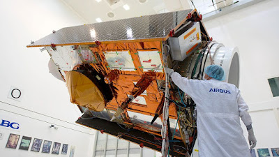
Sentinel-6 Michael Freilich International Sea Level Satellite.


The newest addition to a lengthy series of ocean-monitoring satellites, Sentinel-6 Michael Freilich, becomes the reference satellite for sea level measurements. 


Sentinel-6 Michael Freilich, the newest US-European sea level satellite, became the official reference spacecraft for worldwide sea level observations on March 22. 


  • This implies that data acquired by other satellites will be compared to Sentinel-6 Michael Freilich's information to confirm that they are accurate. 
  • The satellite, which will be launched from Vandenberg Air Force Base in November 2020, will carry on the nearly 30-year legacy of the TOPEX/Poseidon satellite, which began measuring sea surface height in the early 1990s. 
  • Since then, a succession of successor satellites have continued the mission, the most recent of which is Sentinel-6 Michael Freilich. 


Sentinel-6B, its twin, is set to debut in 2025. 


"These missions, including Sentinel-6 Michael Freilich, are the gold standard when it comes to sea level measurements, which are critical for understanding and monitoring climate change," said Josh Willis, project scientist for Sentinel-6 Michael Freilich at NASA's Jet Propulsion Laboratory in Southern California. 


Long-term sea level height measurements are essential for tracking how much and how quickly the waters are rising in a warming environment. 

"We can't lose sight of how much the sea level has risen because if we do, it'll be difficult to anticipate what will happen in the next decades," Willis warned. 

"The unprecedented precision of the sea level measurements provided by this mission ensures not only the continuity of a 30-year data record, but also allows us to better understand climate change and the impact of rising seas on coastal areas and communities," Julia Figa Saldana, ocean altimetry program manager at the European Organization for the Exploitation of Meteorological Satellites, said (EUMETSAT). 


Sentinel-6 Michael Freilich settled into orbit 30 seconds after its predecessor, Jason-3, had launched. 


Since launch, science and engineering teams have spent time ensuring sure Sentinel-6 Michael Freilich was collecting the data it was supposed to be gathering and that the data was correct. 


  • Last year, some of the early data was made accessible for activities such as weather forecasting. 
  • The experts decided that Sentinel-6 Michael Freilich should become the reference satellite for sea level observations following additional validation. 


Jason-3 will be moved into an interleaved orbit later this year by teams. 


  • The ground track – or the strip of Earth that Jason-3's sensors observe as the satellite goes around the world – will run in between the ground tracks of Sentinel-6 Michael Freilich's consecutive orbits from that new point. 
  • Although Jason-3 will no longer function as the official reference sea level satellite, it will continue to measure sea level height from its interleaved orbit. 
  • However, by continuing to gather sea level data, Jason-3 will effectively quadruple the number of measurements observed by Sentinel-6 Michael Freilich on each pass, assisting in substantially improving the spatial resolution of both spacecraft' sea level measurements. 


Sentinel-6 Michael Freilich is one of two satellites that make up the Copernicus Sentinel-6/Jason-CS (Continuity of Service) project. 


It is named after former NASA Earth Science Division Director Michael Freilich. 


  • Sentinel-6/Jason-CS was developed in collaboration with ESA, EUMETSAT, NASA, and NOAA, with financing from the European Commission and performance assistance from CNES (France's National Centre for Space Studies). 
  • EUMETSAT is in charge of spacecraft monitoring and control, as well as the processing of all altimeter scientific data, on behalf of the EU's Copernicus program, with the help of all partner organizations. 
  • The Advanced Microwave Radiometer, the Global Navigation Spacecraft System Radio Occultation, and the Laser Retroreflector Array were all donated by JPL, a subsidiary of Caltech in Pasadena, for each Sentinel-6 satellite. 
  • NASA also provided launch services, ground systems to support the NASA scientific instruments' operations, science data processors for two of the sensors, and assistance for the United States' members of the international Ocean Surface Topography Science Team.


~ Jai Krishna Ponnappan

Find Jai on Twitter | LinkedIn | Instagram


You may also want to read more about Space Exploration and Space Systems here.


Further Reading:


To access data from Sentinel-6 Michael Freilich, visit:


NASA 4-Wheel DuAxel Rover To Explore Moon, Mars, And Asteroids.


The adaptability of a flexible rover that can travel long distances and rappel down hard-to-reach regions of scientific interest was shown in a field test in California's Mojave Desert. 


DuAxel is a pair of Axel robots intended to investigate crater walls, pits, scarps, vents, and other severe environments on the moon, Mars, and beyond. 


  • The robot's capacity to split in half and dispatch one of its parts - a two-wheeled Axle robot - down an otherwise impassable hill is shown in this technological demonstration produced at NASA's Jet Propulsion Laboratory in Southern California. 
  • The rappelling Axel may then seek out regions to research on its own, securely navigate slopes and rough barriers, and return to dock with its other half before traveling to a new location. 
  • Although the rover does not yet have a mission, essential technologies are being developed that might one day assist mankind in exploring the solar system's stony planets and moons.


DuAxel is a development of the Axel system, a flexible series of single-axle rovers meant to traverse high-risk terrain on planetary surfaces, such as steep slopes, boulder fields, and caverns — locations that existing rovers, such as Mars Curiosity, would find difficult or impossible to approach. 


DuAxel's Advantages:


To cover greater distances, two connected Axel Rovers are used: 


  • DuAxel travels large distances by connecting two Axel rovers. 
  • They divide in two when they approach a steep slope or cliff so that one tied Axel may rappel down the steep danger to reach otherwise inaccessible area while the other works as an anchor at the top of the slope. 


Tether that can be retracted: 


  • The Axel rover can lower itself down practically any sort of terrain by reeling and unreeling its built-in rope. 


Greater Maneuverability: 


  • The two-wheeled axle simply spins one of its wheels quicker than the other to turn. 
  • The core cylinder between the wheels houses the sensors, actuators, electronics, power, and payload.


~ Jai Krishna Ponnappan

Find Jai on Twitter | LinkedIn | Instagram


You may also want to read more about Space Exploration and Space Systems here.


References & Further Reading:


JPL Robotics: The Axel Rover System


Educational Resources:


Student Project: Design a Robotic Insect.

Educator Guide: Design a Robotic Insect.


LANDSAT-9: NASA's Latest Earth Observation Satellite In Orbit.


Landsat 9, a NASA satellite designed to monitor the Earth's land surface, successfully launched from Vandenberg Space Force Base in California at 2:12 p.m. EDT Monday, 27th Sept., 2021. 


Landsat 9 was launched from Vandenberg's Space Launch Complex 3E on a United Launch Alliance Atlas V rocket as part of a cooperative mission with the United States Geological Survey (USGS). 


Around 83 minutes after launch, the Svalbard satellite-monitoring ground station in Norway received signals from the spacecraft. 


As it approaches its ultimate orbital height of 438 miles, Landsat 9 is operating as anticipated (705 kilometers). 


NASA Administrator Bill Nelson said, "NASA utilizes the unique assets of our own unparalleled fleet, as well as the equipment of other countries, to study our own planet and its climatic systems." 


“Landsat 9 will take this historic and important worldwide initiative to the next level, with a 50-year data bank to build on. We are excited to collaborate with our colleagues at the USGS and the Department of the Interior on Landsat Next again, since we never stop striving to better understand our planet.” 


Secretary of the Interior Deb Haaland said, "Today's successful launch is a major milestone in the nearly 50-year joint partnership between USGS and NASA, who have partnered for decades to collect valuable scientific information and use that data to shape policy with the utmost scientific integrity." 


Landsat 9 will offer data and images to assist make science-based choices on critical problems such as: 


    1. water usage, 
    2. wildfire effects, 
    3. coral reef degradation, 
    4. glacier and ice-shelf retreat, 
    5. and tropical deforestation as the consequences of the climate crisis increase in the United States and across the world. 


In 1972, the first Landsat satellite was launched. 

Since then, NASA has maintained a Landsat satellite in orbit to gather pictures of the physical stuff that covers our planet's surface, as well as changes in land use. 


Researchers may use these pictures to track agricultural production, forest size and health, water quality, coral reef ecosystem health, and glacier movements, among other things. 

Karen St. Germain, head of NASA's Earth Science Division in Washington, stated, "The Landsat mission is unlike any other." 


“Landsat satellites have been orbiting our globe for almost 50 years, giving an unmatched record of how its surface has altered across timeframes ranging from days to decades. 

We've been able to offer continuous and timely data for customers ranging from farmers to resource managers and scientists because to our collaboration with the USGS. 

In a changing environment, this data may help us comprehend, forecast, and prepare for the future.”


In orbit, Landsat 9 joins its sister spacecraft, Landsat 8. 


Every eight days, the two satellites will work together to gather pictures covering the whole globe. 

“When it comes to monitoring our changing globe, Landsat 9 will be our new eyes in the sky,” said Thomas Zurbuchen, NASA's assistant administrator for science. 


By collaborating with other Landsat satellites and our European Space Agency colleagues who run the Sentintel-2 satellites, we're obtaining a more complete view of Earth than ever before. 

We'll get observations of every given location on our globe every two days thanks to these satellites cooperating in space. 

This is critical for monitoring things like crop growth and assisting decision-makers in monitoring Earth's general health and natural resources.” 


The sensors on board Landsat 9 – the Operational Land Imager 2 (OLI-2) and the Thermal Infrared Sensor 2 (TIRS-2) – measure 11 wavelengths of light reflected or radiated off Earth's surface, including visible and non-visible wavelengths. 


These sensors will record sights over a 115-mile span as the satellite circles (185 kilometers). 


In these pictures, each pixel represents a 98-foot (30-meter) square, about the size of a baseball infield. 

Resource managers will be able to identify most agricultural fields in the United States at that resolution. 

“Launches are always thrilling, and today was no exception,” NASA Landsat 9 project scientist Jeff Masek said. 

“However, the greatest part for me as a scientist will be when the satellite begins providing the data that people have been waiting for, further cementing Landsat's legendary reputation among data users.”


The USGS Earth Resources Observation and Science (EROS) Center in Sioux Falls, South Dakota, analyzes and stores data from the sensors, adding it to the five decades of Landsat data. 

Since its debut in 2008, Landsat pictures and associated data have received over 100 million downloads thanks to this strategy. 


The Landsat 9 mission is overseen by NASA. 


The TIRS-2 instrument was also developed and tested at NASA's Goddard Space Flight Center in Greenbelt, Maryland. 

The mission was launched by NASA's Launch Services Program, which is headquartered at the agency's Kennedy Space Center in Florida. 

The mission will be operated by EROS, which will also handle the ground system and maintain the Landsat archive. 

The OLI-2 instrument was developed and tested by Ball Aerospace in Boulder, Colorado. 

The launch of Landsat 9 will be carried out by United Launch Alliance. 

The Landsat 9 satellite was constructed, fitted with sensors, and tested by Northrop Grumman in Gilbert, Arizona. 


For additional information about Landsat 9, go to:


www.nasa.gov/landsat

www.usgs.gov/landsat


~ Jai Krishna Ponnappan


You may also want to read more about space based systems here.


Meet VIPER, NASA's Lunar Ice Hunter Rover!


NASA chooses a Moon location for an ice-hunting rover. 


NASA is hoping that the robot will confirm the existence of water ice under the surface, which may be turned into rocket fuel for trips to Mars in the future. 


NASA said on Monday that in 2023, it will deploy an ice-seeking rover in the Nobile Crater, an area of the Moon's south pole. 


The space agency is hoping that the robot will confirm the existence of water ice under the surface, which may one day be turned into rocket fuel for trips to Mars and beyond. 

"Nobile Crater is an impact crater near the south pole that formed as a result of a collision with another smaller celestial objects," NASA's planetary science division director Lori Glaze told reporters. 

It's one of the coldest places in the solar system, and it's only been studied from afar using instruments from NASA's Lunar Reconnaissance Orbiter and the Lunar Crater Observation and Sensing Satellite. 


Glazer said, "The rover will get up up and personal with the lunar dirt, even digging several feet deep." The robot is known as the VIPER (Volatiles Investigating Polar Exploration Rover). 


It has the proportions of a golf cart – five feet by five feet by eight feet (1.5 meters by 1.5 meters by 2.5 meters) – and resembles droids from Star Wars. 


It is 950 pounds in weight (430 kilograms). VIPER, unlike rovers on Mars, can be controlled in near real time because to its close proximity to Earth - just around 200,000 miles (300,000 kilometers) or 1.3 light seconds. 

The rover is also quicker, reaching a maximum speed of 0.5 mph (0.8 kph). 


VIPER is a solar-powered robot that has a 50-hour battery, can endure severe temperatures, and can "crab walk" sideways to keep its panels facing toward the Sun to keep charging. 


The VIPER crew aims to discover how frozen water got to the Moon in the first place, how it stayed frozen for billions of years, how it escapes, and where it goes now in terms of the mission's scientific objectives. 


Artemis is America's plan to return people to the Moon, and this mission is part of it. 

The first crewed mission is scheduled for 2024, although it will most likely take occur much later due to delays in many areas.


The ice-hunting Volatiles Investigating Polar Exploration Rover (VIPER) will land near the moon's south pole, just west of Nobile Crater (Sept. 20). 


VIPER will go to the moon in late 2023 on Griffin, a lander developed by Pittsburgh-based Astrobotic and launched atop a SpaceX Falcon Heavy rocket. 

In a statement, Daniel Andrews, VIPER project manager at NASA's Ames Research Center in Silicon Valley, stated, "Selecting a landing location for VIPER is an exciting and significant choice for all of us." 

Andrews said, "Years of research have gone into assessing the arctic area VIPER will investigate." "VIPER is venturing into unknown terrain, guided by science, in order to test theories and disclose crucial data for future human space travel." 


VIPER is a key component of NASA's Artemis program, which seeks to create a long-term, sustainable human presence on and around the moon by the end of the next decade. 


According to NASA experts, achieving this objective would require significant utilization of lunar resources, particularly water ice. 

According to observations by NASA's Lunar Reconnaissance Orbiter and other spacecraft, the moon has a lot of water ice, particularly towards its poles in permanently shadowed regions (PSRs). 

VIPER is intended to validate such research by informing scientists about how much ice is really there and how accessible it is to humans. 


The Nobile site is 36 square miles in size (93 square kilometers). 


The solar-powered VIPER, which weighs 950 pounds (450 kilograms), will measure and describe the water ice under its wheels at various sites throughout Nobile, including PSRs, which are among the coldest places in the solar system. 

VIPER will collect samples from up to 3.3 feet (1 meter) down over the period of at least 100 Earth days, utilizing three spectrometers and a drill. 

"The data VIPER returns will provide lunar scientists around the world with more insight into our moon's cosmic origin, evolution, and history, and it will also help inform future Artemis missions to the moon and beyond by allowing us to better understand the lunar environment in these previously unexplored areas hundreds of thousands of miles away," Thomas Zurbuchen, NASA's Science Mission Directorate, said. 


The VIPER team had chosen four candidate landing locations for the four-wheeled robot near the lunar south pole. 


VIPER project scientist Tony Colaprete of NASA Ames stated during a press briefing today that the other three were a region outside Haworth Crater, a ridgeline extending from Shackleton Crater, and a location near Shoemaker Crater. 

According to Colaprete, all four candidate locations are interesting and seem to be acceptable both scientifically and logistically. 

"Ultimately, it came down to the overall number of working days," he stated at a press conference today, adding that a "working day" is one during which the rover has enough sunlight to function while still being able to communicate with Earth. 

(VIPER's connection with its handlers will be direct; the robot will not utilize a relay satellite.) 


"To complete our mission objectives, we'll need at least 10 or so days," Colaprete added. "At Nobile, we get 40 or more, which is much more than any of these other locations." 


According to NASA officials, the entire cost of VIPER's mission will be about $660 million, including $433.5 million for mission development and operations and $226.5 million for the delivery contract with Astrobotic, which includes the cost of launch. 


NASA's Commercial Lunar Payload Services program was used to sign the delivery contract. 


While VIPER will be NASA's first unmanned rover to land on the moon, it will not be the agency's first wheeled lunar vehicle of any kind: during the last three Apollo missions in 1971 and 1972, NASA deployed astronaut-driven moon buggies.


~ Jai Krishna Ponnappan 


You may also want to read more about Space Exploration, Space Missions and Systems here.


Perseverance Collects Its First Martian Rock Sample


The rock core has been sealed in an airtight titanium sample container and will be accessible in the future. 


The first piece of Martian rock, a core from Jezero Crater little thicker than a pencil, was collected today by NASA's Perseverance rover. 


The historic milestone was verified by data obtained by mission controllers at NASA's Jet Propulsion Laboratory (JPL) in Southern California. 

The core has been sealed in an airtight titanium sample container and will be retrievable in the future. 

NASA and ESA (European Space Agency) are preparing a series of future flights to return the rover's sample tubes back Earth for further analysis as part of the Mars Sample Return program. 


These samples would be the first time materials from another planet have been scientifically identified , chosen and returned to our world. 


NASA Administrator Bill Nelson stated, "NASA has a history of establishing high objectives and then achieving them, demonstrating our nation's dedication to exploration and innovation." 

“This is a huge accomplishment, and I can't wait to see what Perseverance and our team come up with next.” 


Perseverance's mission includes studying the Jezero region to understand the geology and ancient habitability of the area, as well as characterizing the past climate, in addition to identifying and collecting samples of rock and regolith (broken rock and dust) while searching for signs of ancient microscopic life. 


“This is really a momentous moment for all of NASA research,” said Thomas Zurbuchen, assistant administrator for science at NASA Headquarters in Washington. 

“We will be doing the same with the samples Perseverance gathers as part of our Mars Sample Return program, much as the Apollo Moon missions showed the lasting scientific significance of returning samples from other planets for examination here on our planet. 

We anticipate jaw-dropping findings across a wide range of scientific disciplines, including investigation into the issue of whether life ever existed on Mars, using the most advanced science equipment on Earth.”


Perseverance Rover Sample Tubes from NASA. 


The rover's sample tubes, marvels of engineering, must be robust enough to securely transport Red Planet materials back to Earth in perfect shape. 


The tubes in NASA's Mars 2020 Perseverance rover's belly are set to transport the first samples from another planet back to Earth in history. 

Future researchers will utilize these carefully chosen samples of Martian rock and regolith (broken rock and dust) to seek for evidence of possible microbial life on Mars in the past, as well as to address other important questions regarding the planet's history. 

On February 18, 2021, Perseverance will touch down at Mars' Jezero Crater. 


The 43 sample tubes heading to Mars, which are about the size and form of a typical lab test tube, must be lightweight and durable enough to withstand the rigors of the round journey, as well as clean enough that future scientists can be sure that what they're studying is 100 percent Mars. 

"When compared to Mars, Earth is brimming with signs of life," Ken Farley, a Mars 2020 project scientist at Caltech in Pasadena, said. 

"We wanted to get rid of those indications completely so that any residual evidence could be reliably identified and distinguished when the first samples were returned."


Engineered containers have been used to transport samples from other planets since Apollo 11. 


In 1969, Neil Armstrong, Michael Collins, and Buzz Aldrin brought back 47.7 pounds (21.8 kilograms) of samples from the Moon's Sea of Tranquility in two triple-sealed briefcase-size metal cases. 

The rock boxes on Apollo, on the other hand, only had to maintain their contents immaculate for approximately 10 days – from the lunar surface until splashdown – before being taken away to the Lunar Receiving Laboratory. 

The scientific value of Perseverance's sample tubes must be isolated and preserved for more than ten years. 


Sample Return from Mars


Mission scientists will decide when and where NASA's newest rover will dig for samples as it explores Jezero Crater. 


The Sample Caching System, the most complex and most sophisticated device ever launched into space, will be used to package this valuable Martian cargo. 

After the samples have been placed on the Martian surface, NASA will complete the relay by launching two more missions in collaboration with ESA (the European Space Agency). 


The sample return campaign's second mission will dispatch a "fetch" rover to collect the hermetically sealed tubes and transfer them to a dedicated sample return container within the Mars Ascent Vehicle. 


If the Mars 2020 Perseverance rover stays healthy for the duration of the mission, it may transport tubes containing samples to the area of the Mars Ascent Vehicle. 

The tubes will subsequently be sent into orbit by the Mars Ascent Vehicle. 

The last mission will send an orbiter to Mars to meet the enclosed samples, collect them in a highly secure containment capsule, and return them to Earth (as early as 2031). 


Sturdy Containers


Each sample tube is made mostly of titanium and weighs less than 2 ounces (57 grams). 


After Perseverance places the tubes on Mars' surface, a white outer covering protects them from being heated by the Sun, which may change the chemical makeup of the samples. 

The crew will be able to identify the tubes and their contents thanks to laser-etched serial numbers on the outside. 


Each tube must fit within Perseverance's Sample Caching System's stringent constraints, as well as those of future missions. 


"We discovered almost 60 distinct measurements to examine despite the fact that they are less than 6 inches [15.2 cm] long," stated JPL Sample Tube Cognizant Engineer Pavlina Karafillis. 

"Because of the complexities of all the intricate processes they would travel through throughout the Mars Sample Return mission, the tube was considered unsuitable for flight if any measurement was off by approximately the thickness of a human hair." #Jezero is 100 percent pure.# Precision engineering is just one aspect of the task at hand. 


The tubes are also the result of stringent cleaning requirements. 


All of NASA's planetary missions use stringent procedures to avoid the entry of organic, inorganic, or biological material from Earth. 


However, since these tubes may contain evidence that life previously existed elsewhere in the cosmos, the Mars 2020 team needed to further minimize the chance that they could house Earthly artifacts that would obstruct the scientific process. 

Nothing should be in a tube until the Sample Caching System starts filling it with 9 cubic inches (147 cubic centimeters) of Jezero Crater, according to the directive (about the size of a piece of chalk). 


"And they meant it when they said 'nothing,'" Ian Clark, the mission's assistant project systems engineer for sample tube cleaning at JPL, said. 

"For example, we wanted to keep the total quantity of Earth-based organic molecules in a particular sample to fewer than 150 nanograms to accomplish the type of research the project is pursuing. 

We were restricted to fewer than 15 nanograms in a sample for a group of certain chemical components - ones that are highly suggestive of life." A billionth of a gram is referred to as a nanogram. 


A typical thumbprint contains approximately 45,000 nanograms of organics, which is about 300 times the maximum permitted in a sample tube. 


The crew had to rewrite the book on cleaning in order to satisfy the mission's strict requirements. 

"All of our assembly was done in a hyper-clean-room environment, which is really a clean room within a clean room," Clark said. 

"The sample tubes would be cleaned with filtered air blasts, washed with deionized water, and acoustically cleaned with acetone, isopropyl alcohol, and other exotic cleaning chemicals in the interim between assembly processes." The crew would test impurities and bake the tubes after each cleaning for good measure. 


Each of the 43 sample tubes chosen for flight from a field of 93 had produced almost 250 pages of paperwork and 3 terabytes of pictures and movies by the time they were chosen. 


Up to 38 of the tubes onboard Perseverance will be filled with Martian rock and regolith. 

The other five are "witness tubes," which have been filled with molecular and particle contaminants-capturing materials. 

They'll be opened one at a time on Mars, mainly at sample collection sites, to observe the ambient environment and record any Earthly impurities or pollutants from the spacecraft that may be present during sample collection. 

The return and analysis of the sample and witness tubes on Earth will enable the entire range of terrestrial scientific laboratory capabilities to examine the samples, utilizing equipment that are too big and complicated to transport to Mars. 


More Information about the Mission


Astrobiology, particularly the hunt for evidence of ancient microbial life, is a major goal of Perseverance's mission on Mars. 


The rover will study the planet's geology and climatic history, lay the path for human exploration of Mars, and be the first mission to gather and store Martian rock and regolith (broken rock and dust). 

Following missions, which NASA is considering in collaboration with ESA (European Space Agency), would send spacecraft to Mars to retrieve these stored samples from the surface and return them to Earth for further study. 


The Mars 2020 mission is part of a broader program that includes lunar missions in order to prepare for human exploration of Mars. 


NASA's Artemis lunar exploration plans are tasked with sending humans to the Moon by 2024 and establishing a long-term human presence on and around the Moon by 2028. 

The Perseverance rover was constructed and is operated by JPL, which is administered for NASA by Caltech in Pasadena, California.


The Mars 2020 Perseverance mission is part of NASA's Moon to Mars exploration strategy, which includes Artemis lunar missions to assist prepare for human exploration of Mars. 


The Perseverance rover was constructed and is operated by JPL, which is administered for NASA by Caltech in Pasadena, California. 


For additional information about Perseverance, go to: 

mars.nasa.gov/mars2020/ 

nasa.gov/perseverance


Courtesy: NASA.gov


~ Jai Krishna Ponnappan


You may also want to read more about Space Missions and Systems here.


What Is Artificial General Intelligence?

Artificial General Intelligence (AGI) is defined as the software representation of generalized human cognitive capacities that enables the ...